

|
|
![]()
 Point 13S, 15E, X15 |
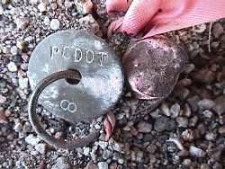
OverviewThis page displays information about geodetic control points developed by the Pima County Department of Transportation and the City of Tucson Department of Transportation & Mobility. Control points are displayed on an interactive PimaMaps map and are linked to point attributes and scanned images of descriptive occupation sheets for each point. For vertical control, see NAVD88 Elevation Circuit. |
These geodetic control points are, at best, third order and are not horizontal control points as defined by ARS 33-133. Monuments existed at the time their geodetic position was determined. The monuments that existed may have been in the proximity of, or may in fact have been, aliquot corners, or section corners. The survey which determined the geodetic positions was for the purpose of controlling the City of Tucson and Pima Association of Governments Orthophoto Project, not for determining whether the monuments represented aliquot corners, or section corners nor to establish horizontal control.
| Geodetic Control Points Map |
Without using the map, you can
 .
.
 .
.
![]()