
![]()
The U.S. Geological Survey (USGS) publishes three seamless statewide USGS Quad Map layers:
|
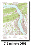 |
You may be familiar with the paper version of these U.S. Geological Survey (USGS) Quad Maps that can be purchased at many map outlets. They are popular with anyone who needs detailed maps that include elevation contours and are often simply called "topo maps". The most common Quad Maps are at 1:24,000 (7.5 Minute) scale.
A digital raster graphic (DRG) is a scanned image of a U.S. Geological Survey standard series topographic map.
Quad Maps include a map "collar" which is a white border that include legend and other information. For this interactive map, the collar has been clipped off and the maps have been georeferenced to align with each other in a seamless grid. Due to variations in the individual Quad Maps, the seams are often visible on the Arizona map.
The USGS produces a whole series of topological maps. The USGS has a good description of the different USGS map series, including the three shown on the Arizona map: 1:24,000 (7.5 Minute), 1:100,000 and 1:250,000. In addition to being at different original paper map scales, each of the three Quad Map layers have other differences. The TopoZone is a good source for viewing USGS Quad Maps for the entire United States, along with more information on the maps, such as map symbols.
Generally, interactive maps are designed to be viewed at any scale. More detail becomes available as you zoom in and identifying labels scale to match the current view. Most users are not aware of this because the map looks "right" regardless of scale.
Each USGS Quad Map series was designed for viewing at one scale -- the scale of the paper map. Other than using a magnifying glass, you can't pan and zoom a paper map. It's just one scale and that's it. With these paper maps scanned as DRGs and input into interactive maps, the map software allows panning and zooming at any scale, close up or far away. This has the effect of showing the maps at viewing scales they weren't designed for. Therefore, you can't see all the detail that was on the original paper map when you are zoomed way out. It's like looking at the paper maps from a distance of 50 feet or so. Conversely, if you zoom way in, you will see a blowup of a very small area as if you were using a magnifying glass on the paper map.
Three spatial reference layers overlaying the quad maps are on by default. You can turn them off to restrict the display to just just the quad maps if they interfere with your view. Those reference layers are Arizona Places, Arizona Streets, and Arizona Administrative Boundaries.
In addition to the U.S. Geological Survey, we thank the BLM GIS Incident Management Team for clipping and georeferencing the USGS maps and photos, and the Arizona State Cartographer's Office for duplicating the stacks of CDs to make them available to us.
![]()