 |
 |
Pima County DOT - City of Tucson DOT
Geodetic Control Points - Horizontal Control Bench Marks
Support Information and Glossary
Point 13S, 14E, J21
Pima County DOT - City of Tucson DOTGeodetic Control Points - Horizontal Control Bench MarksSupport Information and Glossary |
Point 13S, 14E, J21 |
![]()
The Geodetic Control Points are a collection of monuments that were selected at approximate half-mile intervals that were used to control the City of Tucson and Pima Association of Governments Orthophoto Project. These Geodetic Control Points are, at best, third order and are not horizontal control points as defined by ARS 33-133.
|
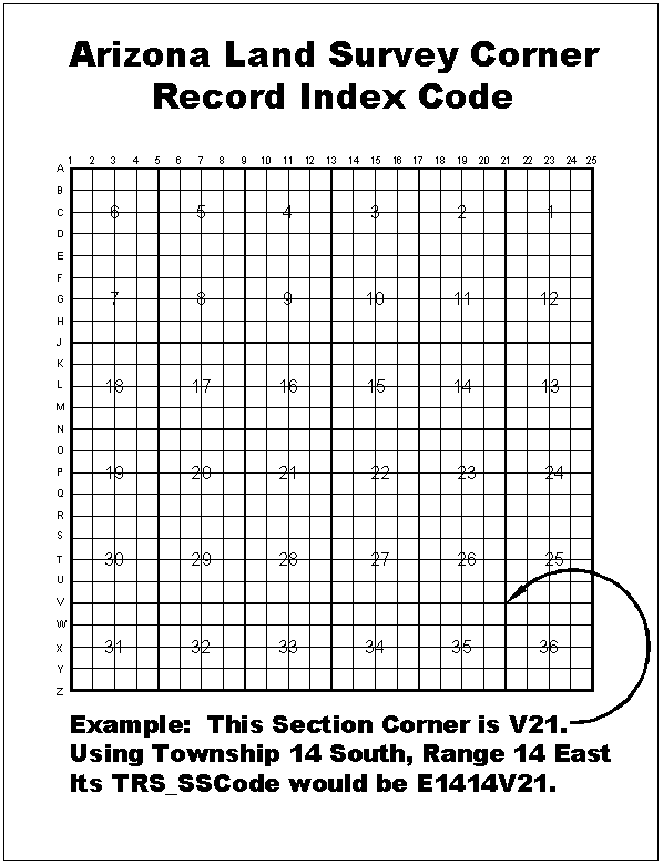
Each of the Geodetic Control Points is referenced to the Public Land Survey System (PLSS) by Township and Range using the Arizona Land Survey Corner Record Index Code. This index code was used to facilitate searching of Geodetic Control Points by Township and Range, and for future referencing of additional Geodetic Control Points as they are established. Each control point has a GPS occupation sheet digital image file, which can be used to recover the field monument that was occupied by the field surveyor. |
The GPS control point terms are suitable for use by the land surveyor community, geomatics and GIS professionals. Most of the control point terms are commonly understood by these professionals, but a brief description is provided here.
| Township, Range | The naming convention used to describe and divide lands according to the Public Land Survey System (PLSS) |
| Index Code | A unique index code that refers to an approximate section corner or aliquot section corner position. See the Arizona Land Survey Corner Record Index Code diagram above. |
| NAD83 | The North America Datum of 1983 (NAD83) |
| NAD27 | The North America Datum of 1927 (NAD27) |
Northing | The Y coordinate value on the Arizona State Plane Coordinate System (Central Zone). |
| Easting | The X coordinate value on the Arizona State Plane Coordinate System (Central Zone). |
| Latitude | The geodetic coordinate measured in degrees along a meridian north or south of the equator. |
| Longitude | The geodetic coordinate measured in degrees east or west of the prime meridian at Greenwich, England. |
| Field Book and Page (FB, PG) | City of Tucson field book and page reference to field observations for the NAVD88 elevation. |
| NAVD88 | North American Vertical Datum of 1988. |
| Orthometric height | The height of the point measured normal to the local level plain and referenced either to NAVD88 or the calculated NGVD29 elevation value. |
| Geoid height | Height of the geoid above or below the ellipsoid (NAD83). A negative value indicates that the geoid is below the ellipsoid. |
| Ellipsoid height | Height above the ellipsoid (NAD83). |
| NGVD29 | National Geodetic Vertical Datum of 1929 |
| Vertcon | An NGS computer program that was used to compute NGVD29 values from NAVD88 values. |
| Vertcon M(Meters) | The computed difference between NAVD88 and NGVD29 in meters. |
| Vertcon F(Feet) | The computed difference between NAVD88 and NGVD29 in feet. |
| Comment | A comment made by the Survey Crew in reference to the control monument. |
| FB, PG | This is the City of Tucson field survey book reference and page number detailing vertical elevation observations. |
| Tile_Name | This is the Geographic Information Systems tile name that is referenced to the Public Land Survey System (PLSS). |
| TRS_SSCODE | This is a unique concatenation string representing the GIS tile name and the Arizona Land Survey Corner Record Index Code position. This is used in the coverage to identify specific geodetic control point locations, and as a reference string to the digital image of the actual geodetic control points field survey session sheet. |
| Combined Factor | Combined Factor is a multiplier for reducing a geodetic distance to ground distance. |
| Bench Mark | A relatively permanent material object, bearing a marked point whose elevation above or below an adopted datum is known. |